|
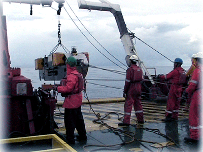
At Petroseis, our range of services includes analogue and multi-channel digital seismic acquisition. Analogue seismic surveys are most suitable for detecting shallow zone sub-seabed sedimentary structures, with depth of penetration ranging from a few metres to a hundred metres depending on the geology. Several systems available in the industry are multi-electrode sparker, boomer, pinger and chirp. Vertical resolutions of less than a metre is achievable, depending on the methods chosen. Analogue sub-bottom seismic profiling is utilized to map the sub-seabed geology and sedimentary structures. data provides shallow zone sub-seabed information such as paleo-channel, shallow fault, sediment thickness, and etc. The data is typically useful for most marine engineering designs.
The applications of analogue seismic survey include:
|
||
|
Side Scan Sonar Side scan sonar is a equipment used for seabed imaging and mapping. It has a wide variety of purposes that range from engineering design and archeological mapping to environmental study. The system consists of a towed fish underwater that send out short high freuency pulses from the transducers mounted on both sides of the fish on to the seafloor. The return pulses detected by the transducers is send back as an electrical signal back to the recording unit on the vessel. The application of side scan sonar are commonly for:
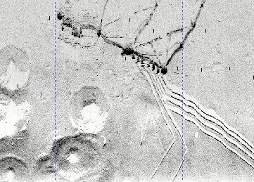
Side scan sonar image showing jack-up rig foot prints, pipelines and platform riser. |
Reflection Seismic Reflection seismic involves generating an acoustic impulse which travels through the water column, subsequently propagating into the underlying geology. Acoustic energy is reflected from the interface between sedimentary layers, due to contrasts in acoustic impedance. This reflected energy is detected and recorded by a hydrophone at the sea surface. The received signals is processed and converted into profile images in a topside recording unit installed in the vessel. The most common geophysical technique for sub-bottom profiling is reflection seismic. Depending on the objectives and requirements, different types of equipments or methods can be used to obtain sub-seabed information.
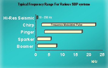
The table below summarized the specifications for various systems in geophysical sub-bottom profiling (SBP). |
|
|
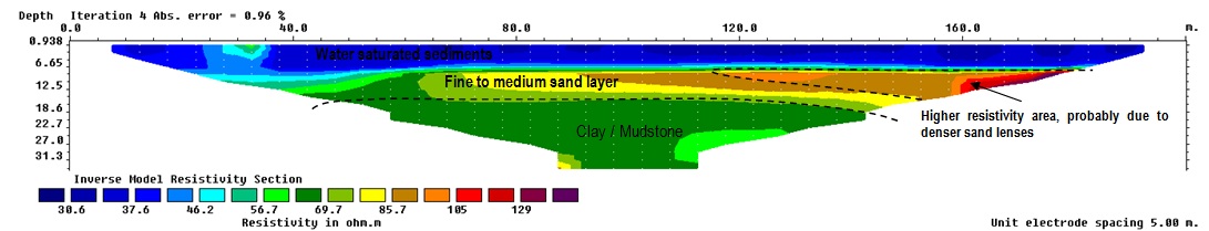
Magnetometer is commonly used to detect variations in total magnetic field for metallic objects on the seabed or buried under the seabed. There are two types of magnetometer used in the industry, the Overhauser magnetometer which generally has a higher resolution than its predecessor proton precession magnetometer. When two or more sensors is combined as in a gradiometer, it provides much finer reading of the earth's magnetic field at any particular spot by measuring the magnetic gradient and thus enables the discovery of even subtle anomalies. The applications of magnetometer are to detect pipelines, cables, submarine archeology, UXO (Unexploded ordnance) or any other metallic objects. Petroseis has successfully conducted numerous iron ore exploration using land magnetometer method. 2D Electrical Resistivity Electrical Resistivity is a survey method widely used for various applications such as groundwater exploration, subsurface structure mapping, ore body detection and etc. This is an electrical geophysical imaging method to measure subsurface apparent resistance distribution by injecting DC current into the ground using 2 current electrodes, and the potential difference is measured using 2 potential electrodes. A series of electrodes were inserted into the ground along the line where the subsurface profiles were to be investigated. The data acquired is later processed to produce a cross profile showing resistivity of the subsurface along the survey line.
|
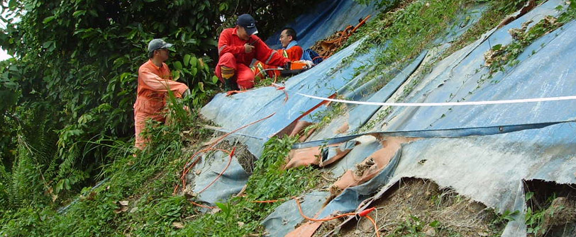
Refraction Seismic Refraction seismic survey involves generating a sound wave at or close to the seabed. The (compressional) sound wave will penetrate the seabed and travel along interfaces between materials of different compaction/density before return to the hydrophone array which is towed behind the seismic source. The travel time for the compressional wave is recorded and analyzed to obtain the velocity information which infers geotechnical characteristics and geology of the subsurface materials. The advantage of refraction seismic survey is the improvement of resolution in the first metres of sediment below seabed. The result is particularly useful for pipeline and cable route survey especially for the assessment for depth of burial. Refraction seismic data is also useful for pre-construction foundation study. The application of refraction seismic prior to geotechnical investigation can significantly reduce the number of soil sampling locations, and hence the cost of project . Electrical Resistivity Survey for Slope stabillity study at Ampang, Selangor, Malaysia.
|
|
Tel : +603 51319899 Fax: +603 51319855 Email: info2022@petroseis.asia PETROSEIS © ALL RIGHTS RESERVED
© 2022 All rights reserve